Dominant classification from survey
EUNIS classification

Dominant classification from survey
EUNIS classification
Show legend...
Show data sources
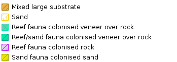
As part of this project, ecological habitat surveys were undertaken to increase knowledge of the mapped extent and condition of habitats within offshore areas of the IFCA district.
This map shows the dominant habitats found during these surveys. Detailed information can be found in the report to the IFCA: Ashley, M., Rees, S., Mullier, T., Reed, B., Cartwright, A., Holmes, L., Sheehan, E., 2020. Isles of Scilly Natural Capital Asset and Risk Register to Inform Management of Isles of Scilly Fisheries Resources. A report by research staff the Marine Institute at the University of Plymouth.
This project was funded by EMFF and NERC- SWEEP NE/P011217/1
Additional data sources: EUSeaMap, habitat data collected by Natural England. Contains public sector information licensed under the Open Government Licence v2.0 (UKHO) and OS data © Crown copyright and database right (2020).